|
| at: |
Talladega National Forest |
Data from USFS GIS
 show on map
 animate
Trail users:


Elevation Profile
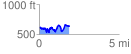
 1.896331 mi
 428.33 ft
 411.63 ft
 16.69 ft
 4.28 %
GPX Downloads: Track Route
![]()
|
| at: |
Talladega National Forest |
show on map
animate
1.896331 mi
428.33 ft
411.63 ft
16.69 ft
4.28 %