|
| at: |
Talladega National Forest |
Data from USFS GIS
 show on map
 animate
Trail users:


Elevation Profile
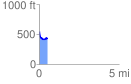
 0.535077 mi
 35.20 ft
 153.62 ft
 -118.41 ft
 5.44 %
GPX Downloads: Track Route
![]()
|
| at: |
Talladega National Forest |
show on map
animate
0.535077 mi
35.20 ft
153.62 ft
-118.41 ft
5.44 %