|
| at: |
Talladega National Forest |
Data from USFS GIS
 show on map
 animate
Trail users:


Elevation Profile
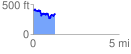
 1.281067 mi
 233.76 ft
 275.17 ft
 -41.41 ft
 4.07 %
GPX Downloads: Track Route
![]()
|
| at: |
Talladega National Forest |
show on map
animate
1.281067 mi
233.76 ft
275.17 ft
-41.41 ft
4.07 %