|
| at: |
Talladega National Forest |
Data from USFS GIS
 show on map
 animate
Trail users:


Elevation Profile
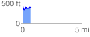
 0.671296 mi
 126.38 ft
 168.47 ft
 -42.09 ft
 4.75 %
GPX Downloads: Track Route
![]()
|
| at: |
Talladega National Forest |
show on map
animate
0.671296 mi
126.38 ft
168.47 ft
-42.09 ft
4.75 %