|
| at: |
Talladega National Forest |
Data from USFS GIS
 show on map
 animate
Trail users:


Elevation Profile
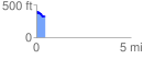
 0.476731 mi
 24.34 ft
 107.82 ft
 -83.47 ft
 4.28 %
GPX Downloads: Track Route
![]()
|
| at: |
Talladega National Forest |
show on map
animate
0.476731 mi
24.34 ft
107.82 ft
-83.47 ft
4.28 %