|
| at: |
Talladega National Forest |
Data from USFS GIS
 show on map
 animate
Trail users:


Elevation Profile
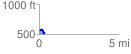
 0.353625 mi
 56.89 ft
 78.58 ft
 -21.69 ft
 4.21 %
GPX Downloads: Track Route
![]()
|
| at: |
Talladega National Forest |
show on map
animate
0.353625 mi
56.89 ft
78.58 ft
-21.69 ft
4.21 %