| at: |
Talladega National Forest |
Data from USFS GIS
 show on map
 animate
Trail users:


Elevation Profile
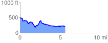
 5.668935 mi
 642.57 ft
 896.53 ft
 -253.96 ft
 3.00 %
GPX Downloads: Track Route
![]()
| at: |
Talladega National Forest |
show on map
animate
5.668935 mi
642.57 ft
896.53 ft
-253.96 ft
3.00 %