|
| at: |
Talladega National Forest |
Data from USFS GIS
 show on map
 animate
Trail users:


Elevation Profile
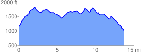
 13.868553 mi
 2473.05 ft
 2678.84 ft
 -205.79 ft
 3.66 %
GPX Downloads: Track Route
![]()
|
| at: |
Talladega National Forest |
show on map
animate
13.868553 mi
2473.05 ft
2678.84 ft
-205.79 ft
3.66 %