|
| at: |
Talladega National Forest |
Data from USFS GIS
 show on map
 animate
Trail users:


Elevation Profile
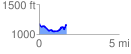
 1.724196 mi
 192.53 ft
 210.79 ft
 -18.26 ft
 2.32 %
GPX Downloads: Track Route
![]()
|
| at: |
Talladega National Forest |
show on map
animate
1.724196 mi
192.53 ft
210.79 ft
-18.26 ft
2.32 %