|
| at: |
Talladega National Forest |
Data from USFS GIS
 show on map
 animate
Trail users:


Elevation Profile
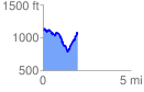
 1.974294 mi
 535.76 ft
 574.91 ft
 -39.15 ft
 5.52 %
GPX Downloads: Track Route
![]()
|
| at: |
Talladega National Forest |
show on map
animate
1.974294 mi
535.76 ft
574.91 ft
-39.15 ft
5.52 %