|
| at: |
Talladega National Forest |
Data from USFS GIS
 show on map
 animate
Trail users:


Elevation Profile
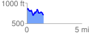
 1.513279 mi
 274.15 ft
 407.34 ft
 -133.19 ft
 5.10 %
GPX Downloads: Track Route
![]()
|
| at: |
Talladega National Forest |
show on map
animate
1.513279 mi
274.15 ft
407.34 ft
-133.19 ft
5.10 %