|
| at: |
Talladega National Forest |
Data from USFS GIS
 show on map
 animate
Trail users:


Elevation Profile
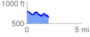
 2.016388 mi
 252.61 ft
 419.09 ft
 -166.48 ft
 3.94 %
GPX Downloads: Track Route
![]()
|
| at: |
Talladega National Forest |
show on map
animate
2.016388 mi
252.61 ft
419.09 ft
-166.48 ft
3.94 %