| at: |
Talladega National Forest |
Data from USFS GIS
 show on map
 animate
Trail users:


Elevation Profile
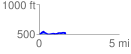
 1.668263 mi
 89.08 ft
 86.52 ft
 2.56 ft
 1.01 %
GPX Downloads: Track Route
![]()
| at: |
Talladega National Forest |
show on map
animate
1.668263 mi
89.08 ft
86.52 ft
2.56 ft
1.01 %