|
| at: |
Talladega National Forest |
Data from USFS GIS
 show on map
 animate
Trail users:


Elevation Profile
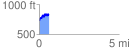
 0.614860 mi
 190.36 ft
 97.85 ft
 92.51 ft
 5.86 %
GPX Downloads: Track Route
![]()
|
| at: |
Talladega National Forest |
show on map
animate
0.614860 mi
190.36 ft
97.85 ft
92.51 ft
5.86 %