|
| at: |
Talladega National Forest |
Data from USFS GIS
 show on map
 animate
Trail users:


Elevation Profile
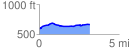
 3.156641 mi
 148.20 ft
 83.83 ft
 64.37 ft
 0.89 %
GPX Downloads: Track Route
![]()
|
| at: |
Talladega National Forest |
show on map
animate
3.156641 mi
148.20 ft
83.83 ft
64.37 ft
0.89 %