|
| at: |
Talladega National Forest |
Data from USFS GIS
 show on map
 animate
Trail users:


Elevation Profile
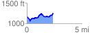
 2.398275 mi
 341.86 ft
 253.89 ft
 87.98 ft
 2.70 %
GPX Downloads: Track Route
![]()
|
| at: |
Talladega National Forest |
show on map
animate
2.398275 mi
341.86 ft
253.89 ft
87.98 ft
2.70 %