|
| at: |
Talladega National Forest |
Data from USFS GIS
 show on map
 animate
Trail users:


Elevation Profile
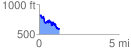
 1.256549 mi
 211.39 ft
 442.64 ft
 -231.25 ft
 6.67 %
GPX Downloads: Track Route
![]()
|
| at: |
Talladega National Forest |
show on map
animate
1.256549 mi
211.39 ft
442.64 ft
-231.25 ft
6.67 %