|
| at: |
Talladega National Forest |
Data from USFS GIS
 show on map
 animate
Trail users:


Elevation Profile
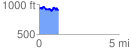
 1.228972 mi
 175.69 ft
 199.84 ft
 -24.15 ft
 3.08 %
GPX Downloads: Track Route
![]()
|
| at: |
Talladega National Forest |
show on map
animate
1.228972 mi
175.69 ft
199.84 ft
-24.15 ft
3.08 %