|
| at: |
Talladega National Forest |
Data from USFS GIS
 show on map
 animate
Trail users:


Elevation Profile
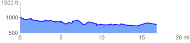
 17.632863 mi
 1128.42 ft
 1314.47 ft
 -186.05 ft
 1.41 %
GPX Downloads: Track Route
![]()
|
| at: |
Talladega National Forest |
show on map
animate
17.632863 mi
1128.42 ft
1314.47 ft
-186.05 ft
1.41 %