|
| at: |
Talladega National Forest |
Data from USFS GIS
 show on map
 animate
Trail users:


Elevation Profile
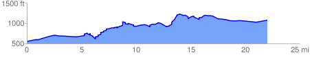
 23.867940 mi
 2290.16 ft
 1731.09 ft
 559.07 ft
 1.82 %
GPX Downloads: Track Route
![]()
|
| at: |
Talladega National Forest |
show on map
animate
23.867940 mi
2290.16 ft
1731.09 ft
559.07 ft
1.82 %