|
| at: |
Talladega National Forest |
Data from USFS GIS
 show on map
 animate
Trail users:


Elevation Profile
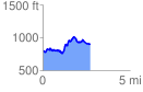
 2.762119 mi
 524.94 ft
 441.84 ft
 83.10 ft
 3.60 %
GPX Downloads: Track Route
![]()
|
| at: |
Talladega National Forest |
show on map
animate
2.762119 mi
524.94 ft
441.84 ft
83.10 ft
3.60 %