|
| at: |
Talladega National Forest |
Data from USFS GIS
 show on map
 animate
Trail users:


Elevation Profile
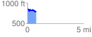
 0.753194 mi
 102.05 ft
 193.25 ft
 -91.20 ft
 4.86 %
GPX Downloads: Track Route
![]()
|
| at: |
Talladega National Forest |
show on map
animate
0.753194 mi
102.05 ft
193.25 ft
-91.20 ft
4.86 %