|
| at: |
Talladega National Forest |
Data from USFS GIS
 show on map
 animate
Trail users:


Elevation Profile
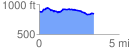
 3.440776 mi
 204.64 ft
 256.28 ft
 -51.64 ft
 1.41 %
GPX Downloads: Track Route
![]()
|
| at: |
Talladega National Forest |
show on map
animate
3.440776 mi
204.64 ft
256.28 ft
-51.64 ft
1.41 %