|
| at: |
Talladega National Forest |
Data from USFS GIS
 show on map
 animate
Trail users:


Elevation Profile
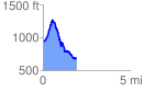
 1.925307 mi
 423.60 ft
 665.13 ft
 -241.53 ft
 6.54 %
GPX Downloads: Track Route
![]()
|
| at: |
Talladega National Forest |
show on map
animate
1.925307 mi
423.60 ft
665.13 ft
-241.53 ft
6.54 %