|
| at: |
Talladega National Forest |
Data from USFS GIS
 show on map
 animate
Trail users:


Elevation Profile
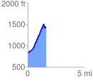
 1.618454 mi
 690.52 ft
 82.02 ft
 608.50 ft
 8.08 %
GPX Downloads: Track Route
![]()
|
| at: |
Talladega National Forest |
show on map
animate
1.618454 mi
690.52 ft
82.02 ft
608.50 ft
8.08 %