|
| at: |
Talladega National Forest |
Data from USFS GIS
 show on map
 animate
Trail users:


Elevation Profile
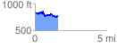
 1.608391 mi
 156.27 ft
 217.31 ft
 -61.04 ft
 2.56 %
GPX Downloads: Track Route
![]()
|
| at: |
Talladega National Forest |
show on map
animate
1.608391 mi
156.27 ft
217.31 ft
-61.04 ft
2.56 %