|
| at: |
Talladega National Forest |
Data from USFS GIS
 show on map
 animate
Trail users:


Elevation Profile
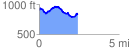
 2.447829 mi
 283.54 ft
 352.77 ft
 -69.23 ft
 2.73 %
GPX Downloads: Track Route
![]()
|
| at: |
Talladega National Forest |
show on map
animate
2.447829 mi
283.54 ft
352.77 ft
-69.23 ft
2.73 %