|
| at: |
Talladega National Forest |
Data from USFS GIS
 show on map
 animate
Trail users:


Elevation Profile
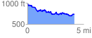
 4.193576 mi
 548.32 ft
 811.22 ft
 -262.89 ft
 3.66 %
GPX Downloads: Track Route
![]()
|
| at: |
Talladega National Forest |
show on map
animate
4.193576 mi
548.32 ft
811.22 ft
-262.89 ft
3.66 %