|
| at: |
Talladega National Forest |
Data from USFS GIS
 show on map
 animate
Trail users:


Elevation Profile
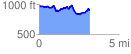
 3.201609 mi
 431.30 ft
 509.95 ft
 -78.65 ft
 3.02 %
GPX Downloads: Track Route
![]()
|
| at: |
Talladega National Forest |
show on map
animate
3.201609 mi
431.30 ft
509.95 ft
-78.65 ft
3.02 %