|
| at: |
Talladega National Forest |
Data from USFS GIS
 show on map
 animate
Trail users:


Elevation Profile
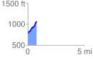
 0.778923 mi
 293.36 ft
 20.72 ft
 272.64 ft
 7.13 %
GPX Downloads: Track Route
![]()
|
| at: |
Talladega National Forest |
show on map
animate
0.778923 mi
293.36 ft
20.72 ft
272.64 ft
7.13 %