|
| at: |
Talladega National Forest |
Data from USFS GIS
 show on map
 animate
Trail users:


Elevation Profile
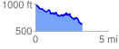
 3.257348 mi
 315.39 ft
 672.17 ft
 -356.79 ft
 3.91 %
GPX Downloads: Track Route
![]()
|
| at: |
Talladega National Forest |
show on map
animate
3.257348 mi
315.39 ft
672.17 ft
-356.79 ft
3.91 %