|
| at: |
Talladega National Forest |
Data from USFS GIS
 show on map
 animate
Trail users:


Elevation Profile
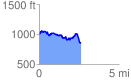
 2.665107 mi
 352.85 ft
 499.68 ft
 -146.83 ft
 3.55 %
GPX Downloads: Track Route
![]()
|
| at: |
Talladega National Forest |
show on map
animate
2.665107 mi
352.85 ft
499.68 ft
-146.83 ft
3.55 %