|
| at: |
Talladega National Forest |
Data from USFS GIS
 show on map
 animate
Trail users:


Elevation Profile
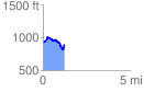
 1.230293 mi
 210.75 ft
 234.32 ft
 -23.57 ft
 3.61 %
GPX Downloads: Track Route
![]()
|
| at: |
Talladega National Forest |
show on map
animate
1.230293 mi
210.75 ft
234.32 ft
-23.57 ft
3.61 %