|
| at: |
Talladega National Forest |
Data from USFS GIS
 show on map
 animate
Trail users:


Elevation Profile
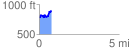
 0.764375 mi
 213.80 ft
 84.94 ft
 128.86 ft
 5.30 %
GPX Downloads: Track Route
![]()
|
| at: |
Talladega National Forest |
show on map
animate
0.764375 mi
213.80 ft
84.94 ft
128.86 ft
5.30 %