|
| at: |
Talladega National Forest |
Data from USFS GIS
 show on map
 animate
Trail users:


Elevation Profile
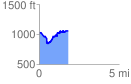
 1.810318 mi
 364.68 ft
 339.50 ft
 25.19 ft
 3.82 %
GPX Downloads: Track Route
![]()
|
| at: |
Talladega National Forest |
show on map
animate
1.810318 mi
364.68 ft
339.50 ft
25.19 ft
3.82 %