|
| at: |
Talladega National Forest |
Data from USFS GIS
 show on map
 animate
Trail users:


Elevation Profile
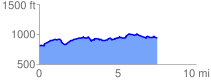
 7.607985 mi
 729.07 ft
 568.07 ft
 161.00 ft
 1.81 %
GPX Downloads: Track Route
![]()
|
| at: |
Talladega National Forest |
show on map
animate
7.607985 mi
729.07 ft
568.07 ft
161.00 ft
1.81 %