|
| at: |
Talladega National Forest |
Data from USFS GIS
 show on map
 animate
Trail users:


Elevation Profile
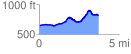
 3.784909 mi
 412.82 ft
 243.55 ft
 169.27 ft
 2.07 %
GPX Downloads: Track Route
![]()
|
| at: |
Talladega National Forest |
show on map
animate
3.784909 mi
412.82 ft
243.55 ft
169.27 ft
2.07 %