|
| at: |
Talladega National Forest |
Data from USFS GIS
 show on map
 animate
Trail users:


Elevation Profile
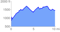
 9.957285 mi
 2384.48 ft
 1788.31 ft
 596.17 ft
 4.54 %
GPX Downloads: Track Route
![]()
|
| at: |
Talladega National Forest |
show on map
animate
9.957285 mi
2384.48 ft
1788.31 ft
596.17 ft
4.54 %