| at: |
Talladega National Forest |
Data from USFS GIS
 show on map
 animate
Trail users:


Elevation Profile
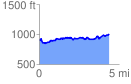
 4.389156 mi
 546.98 ft
 457.27 ft
 89.71 ft
 2.36 %
GPX Downloads: Track Route
![]()
| at: |
Talladega National Forest |
show on map
animate
4.389156 mi
546.98 ft
457.27 ft
89.71 ft
2.36 %