| at: |
Talladega National Forest |
Data from USFS GIS
 show on map
 animate
Trail users:


Elevation Profile
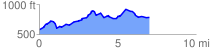
 7.044071 mi
 726.95 ft
 523.28 ft
 203.66 ft
 1.95 %
GPX Downloads: Track Route
![]()
| at: |
Talladega National Forest |
show on map
animate
7.044071 mi
726.95 ft
523.28 ft
203.66 ft
1.95 %