| at: |
Talladega National Forest |
Data from USFS GIS
 show on map
 animate
Trail users:


Elevation Profile
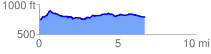
 6.793859 mi
 384.33 ft
 349.52 ft
 34.81 ft
 1.07 %
GPX Downloads: Track Route
![]()
| at: |
Talladega National Forest |
show on map
animate
6.793859 mi
384.33 ft
349.52 ft
34.81 ft
1.07 %