|
| at: |
Talladega National Forest |
Data from USFS GIS
 show on map
 animate
Trail users:


Elevation Profile
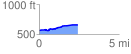
 2.431082 mi
 132.50 ft
 33.56 ft
 98.94 ft
 1.03 %
GPX Downloads: Track Route
![]()
|
| at: |
Talladega National Forest |
show on map
animate
2.431082 mi
132.50 ft
33.56 ft
98.94 ft
1.03 %