|
| at: |
Talladega National Forest |
Data from USFS GIS
 show on map
 animate
Trail users:


Elevation Profile
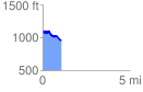
 1.062327 mi
 126.49 ft
 239.28 ft
 -112.80 ft
 4.27 %
GPX Downloads: Track Route
![]()
|
| at: |
Talladega National Forest |
show on map
animate
1.062327 mi
126.49 ft
239.28 ft
-112.80 ft
4.27 %