|
| at: |
Talladega National Forest |
Data from USFS GIS
 show on map
 animate
Trail users:


Elevation Profile
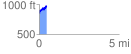
 0.457980 mi
 161.62 ft
 32.01 ft
 129.61 ft
 6.68 %
GPX Downloads: Track Route
![]()
|
| at: |
Talladega National Forest |
show on map
animate
0.457980 mi
161.62 ft
32.01 ft
129.61 ft
6.68 %