|
| at: |
Talladega National Forest |
Data from USFS GIS
 show on map
 animate
Trail users:


Elevation Profile
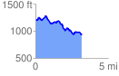
 3.210593 mi
 384.42 ft
 635.87 ft
 -251.45 ft
 3.75 %
GPX Downloads: Track Route
![]()
|
| at: |
Talladega National Forest |
show on map
animate
3.210593 mi
384.42 ft
635.87 ft
-251.45 ft
3.75 %