|
| at: |
Talladega National Forest |
Data from USFS GIS
 show on map
 animate
Trail users:


Elevation Profile
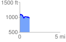
 1.227324 mi
 112.11 ft
 205.65 ft
 -93.53 ft
 3.17 %
GPX Downloads: Track Route
![]()
|
| at: |
Talladega National Forest |
show on map
animate
1.227324 mi
112.11 ft
205.65 ft
-93.53 ft
3.17 %