|
| at: |
Talladega National Forest |
Data from USFS GIS
 show on map
 animate
Trail users:


Elevation Profile
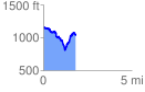
 1.815511 mi
 409.74 ft
 514.84 ft
 -105.10 ft
 5.37 %
GPX Downloads: Track Route
![]()
|
| at: |
Talladega National Forest |
show on map
animate
1.815511 mi
409.74 ft
514.84 ft
-105.10 ft
5.37 %