|
| at: |
Talladega National Forest |
Data from USFS GIS
 show on map
 animate
Trail users:


Elevation Profile
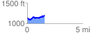
 1.586177 mi
 239.98 ft
 190.88 ft
 49.10 ft
 2.87 %
GPX Downloads: Track Route
![]()
|
| at: |
Talladega National Forest |
show on map
animate
1.586177 mi
239.98 ft
190.88 ft
49.10 ft
2.87 %