|
| at: |
Talladega National Forest |
Data from USFS GIS
 show on map
 animate
Trail users:


Elevation Profile
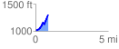
 0.857937 mi
 352.22 ft
 58.98 ft
 293.24 ft
 7.78 %
GPX Downloads: Track Route
![]()
|
| at: |
Talladega National Forest |
show on map
animate
0.857937 mi
352.22 ft
58.98 ft
293.24 ft
7.78 %