|
| at: |
Talladega National Forest |
Data from USFS GIS
 show on map
 animate
Trail users:


Elevation Profile
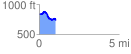
 1.048566 mi
 74.31 ft
 189.53 ft
 -115.22 ft
 3.42 %
GPX Downloads: Track Route
![]()
|
| at: |
Talladega National Forest |
show on map
animate
1.048566 mi
74.31 ft
189.53 ft
-115.22 ft
3.42 %